We know by now that the insights produced by any AI algorithm are only as strong as the data that feeds and informs it. But in some industries, like infrastructure, this data isn’t easy to come by, and in many cases can’t be easily interpreted by computers. Much of this data lives in unstructured silos, or potentially doesn’t exist in digital form. However, today more and more new data types and sources are emerging thanks to advancing technology in satellite imagery, autonomous drones and image recognition.
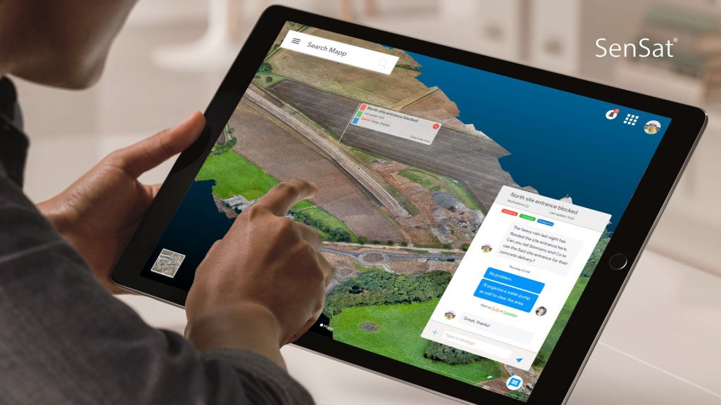
UK-based AI startup SenSat was recently crowned #1 on the Crunchbase list of top European AI companies, and just announced a seed round of $4.5M. The funding will be used to build out the technology behind their Mapp® platform, creating what they call “real-time simulated reality.” Using new technology, they can photograph the real world “at a level of detail that goes beyond satellite imagery.” Their simulations are then injected with data that computers can understand and interact with, enabling computers to more easily solve real world problems, and helping humans make better informed decisions.
According to SenSat CEO James Dean, the company’s simulations will allow significant large-scale machine learning and data analysis – starting with the infrastructure construction space.
We spoke with James Dean for more about the technology powering SenSat’s beta Mapp® platform, how this data can be used to inform algorithms in the tech space and where he sees the opportunity for this sort of external data to enable better decision-making in the future.
Real world meets machine: How SenSat works
“SenSat is making it possible for computers to understand the real world through the lens of highly detailed simulated realities, to learn how things work and to change the way we make decisions,” Dean said. “We do this by creating digital replicas of real world locations, then infusing real time spatial data-sets with a high degree of statistical accuracy from both open and proprietary sources. The resulting simulations are realistic and fully digital, allowing large scale machine learning and data analysis at an unprecedented scale.”
The technology powering SenSat is what the team calls ‘Visual Intelligence’ – a subset of Artificial Intelligence focussed on teaching computers how to understand and interact with the real world.

Use cases for real world simulation data
SenSat’s simulated reality platform Mapp® allows companies operating in physical domains to make more informed decisions based on multiple variables at large scale and complexity.
To date, SenSat has supported over GBP £3.5B in infrastructure builds, including projects like Highways England and National Grid assets.
Dean identified a recent use case involving landscaping production brand Wienerberger. Their team needed high resolution topographical data to be used as the basis for planning design, 3D digital renderings and ongoing Building Information Modeling (BIM) of a housing development.
“Using its autonomous mapping drones, SenSat was able to collect 22,500,000 data points in 36 minutes of flight, covering 0.18 square km, accurate to 17mm by Root Mean Square (RMS) measurements. While a manual surveyor risks error and injury crossing the terrain of the property, SenSat licensed operators collected 15,000x more data points and remained safely stationed in place through the duration of the scan.”
With SenSat’s Mapp® platform, the Wienerberger teams had real-time collaborative access to the development’s digital simulation without ever having to physically visit the site. “While old technology would be incapable of storing or processing such enormous amounts of data, Mapp® made it both accessible and simple to use. Using Mapp®, Wienerberger could complete remote land measurements, make site assessments for planning and design and integrate design data onto topographical data – all in a few clicks.”
The most complex real-time city simulation ever made
In a recent project, SenSat worked closely with Cambridge’s city council to map the city’s infrastructure, traffic, pedestrians and other layers in the most complex real-time city simulation ever created. “Within 5 days the team created the highest resolution 3D representation of Cambridge, deployed over 500 proprietary sensors that measure over thirty types of environmental data and infused real time open data provided by the city council.”
Using virtual representations of the real world as algorithmic training data
According to Dean, data scientists developing AI algorithms for real world applications often end up seeing failed results, because the data feeding the AI is based on environments that aren’t wholly representative of the real world situations they will encounter.
“The way we train AI today involves creating virtual representations of the real world in game environments. This takes a long time and fundamentally is not representative of how complex the real world is. The result is that when we try to deploy AI algorithms trained in these game environments in the real world, they fail.”
Alternatively SenSat’s simulated realities replicate exactly what is happening in the real world, offering a much more sensible environment to trial developing technologies. “It helps the reinforcement learning feedback loop by providing access to real world scenarios.”
SenSat’s technology also enables developers to ask increasingly more complex questions which they wouldn’t currently be able to answer using AI alone. “The resolution of Mapp® enables us to ask questions whereby the answers rely on many connected variables at large scale. This means that we can ask questions such as, ‘Can you design me a road across these fields?’ or, ‘Where should I place solar panels within New York in order to get the maximum efficiency?’ Because the system has the data, the contextual understanding, and the question, it has all the necessary ingredients to work out the solution.”
Real world simulation and the future of decision-making
“We believe that the ability for computers to understand and interact with the real world is the next major phase in technology. It will enhance the human experience and change how we understand the real world, helping us to make better decisions,” Dean said.
“We all live in a physical world, so inherently everything we do is affected by or happens to affect the physical world. As such it means they can knowledge share and converse. So for example you may have an AI working in commodity trading in financial markets (a very non physical sector). Now for the first time it can talk with an AI working in agricultural plant health monitoring, and the insights it gains will mean that it can make better decisions about upcoming plant yields.”
SenSat’s Mapp® platform is now in beta and being used by over 28 tier 1 construction companies in the UK and US.
One of the benefits of training AIs the way we do is that we create a common language between AIs whereby they can discuss the real world together
About SenSat CEO James Dean
James is a technology entrepreneur fascinated by the way the world works. He founded SenSat as a way to enable the greatest step change since the internet: the digitisation of the physical world. SenSat allows computers to interact with the real world in their own language, making important information accessible to everyone.
James received a BSc from King’s College London in Geography and a minor in Astrophysics from The University of California, Irvine. His speciality lies in Satellite Sensing and Earth monitoring where he worked with NASA’s LandSAT and MODIS satellites.
For actionable insights from around the web and the latest live case studies. Join the weekly Outside Insight briefing for free. Get all the key insights direct to your inbox when you subscribe today.
